
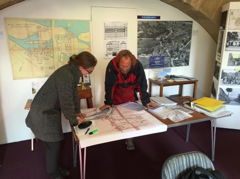
Photo: Joe Elliot- Nicola Whyte and Brian Deer situate themselves on the map
Arriving in Belper by train for the first time in the rain, it’s easy to not realise you’ve arrived in town at all. The whole train line was cut into the ground, in a “trench” requested by Jedediah Strutt in the nineteenth-century, so that the then-new trains didn’t ruin the scenery. So unbeknownst to me, this was my first encounter with the planning and influence of the Strutt family in Belper. The Strutt Mill was where I was heading for the day to meet with Mary Smedley and Brian Douglas, fountains of knowledge about all things Belper and Strutt.
Since my visits to the archives I’ve been working with architecture student Charlotte Eley, giving her the mapping information I’ve recorded to help produce a base map showing how the Derwent River was altered with the construction of factories in the Industrial Revolution. She’s layered two maps on top of each other, one from before the factory was built and one after, to show how the Strutt family had altered the river to suit their needs. And as it becomes clear on our base map, they did so quite severely, with the construction of a system of weirs, channels and sluices to power their mill. Now the job was to get extra information about the history of the area to annotate the map. So when it is hopefully used for a future display it gives a clear idea to the viewer of how the area has changed which is harder to picture, and less interesting to look at, when just described in a book.
Landscape historian Nicola Whyte, from the Stories of Change Team and I set up in the former wheel pit at the North Mill. Frankly we couldn’t have hoped for better sources of information than Brian and Mary. Brian, a cartographer and historian, gave us a guided tour around outside of the mill and its watercourses which I frantically tried to memorise as I’d foolishly left my pen and paper inside in the dry. Out in the rain, I was matching what I’d seen on the map to the real thing which is something that has made the work undeniably more fascinating. Staring at dusty maps all day can be a bit of a drag but seeing it in front of you gives an inexplicable buzz.
After our tour we headed back inside and I desperately tried to keep up with Mary’s oral history of Belper covering everything from river alterations, the housing provided by the Strutt family for their workers, and donkey racing! Overall, we came away with a wealth of information about Belper and the factory system scribbled all over the draft map so now when this information is presented more neatly on the finished version we’ll have a great visual aid for anyone wanting to understand this history of this fascinating town.
Later, as I descended back into the railway trench and Belper disappeared from sight once more, just as Strutt had requested, I couldn’t help but look at the whole place differently. When our project is finished, hopefully plenty of other visitors will feel the same.

Pingback: Bringing Energy Home: Mapping Sheffield and the Don | Future Works·